Kallar Syedan Tehsil: History, Geography
Kallar Syedan Tehsil lies in the eastern part of Rawalpindi District in the Punjab province of Pakistan, covering an area of approximately 421 square kilometres of the Potohar Plateau. It is the most recently created tehsil in the district, having been carved out of the older Kahuta Tehsil and formally established on 1 July 2004. The town of Kallar Syedan serves as the tehsil headquarters and its main commercial centre, lying along the N-38 road that connects Rawalpindi to Azad Kashmir through the Potohar uplands.
Geography and Physical Setting
The tehsil sits on the classic undulating terrain of the Potohar Plateau, where rolling hills, shallow valleys and seasonal streams define the landscape. It lies at coordinates 33°22’N, 73°24’E and sits at an elevation of approximately 520 metres above sea level. The countryside is marked by rainfed agricultural land, thin soils over sandstone and shale, and scattered woodland cover typical of the sub-Himalayan foothills. Seasonal nullahs carry monsoon runoff through the valleys, and the tehsil benefits from a more pronounced rainfall pattern than the drier western parts of Rawalpindi District, which supports wheat cultivation and kitchen gardening across many villages.
The tehsil shares boundaries with Kahuta Tehsil to the south and southwest, and its eastern edge meets the Dadyal Tehsil of Azad Kashmir. The Kallar Syedan Road links the east of the city to Choha Khalsa and onward to Dadyal Tehsil of Azad Kashmir, making the tehsil a natural transit corridor between Punjab and Pakistani-administered Kashmir. A bypass road south of the main town has been developed to ease traffic through the urban centre. The landscape transitions from relatively flat agricultural plains near the tehsil headquarters to more hilly terrain as one moves northeast towards the Azad Kashmir border.
History of Kallar Syedan
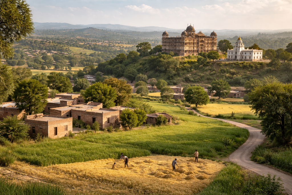
Kallar Syedan’s existence dates back approximately 1,200 years, and the town rose to particular prominence during the period of Sikh rule, as evidenced today by the havelis, gurdwaras, and small fortresses that can be found across the Rawalpindi district. The settlement carries a rich layered history that reflects the successive waves of political and cultural influence that swept through the Potohar region over the centuries.
The most significant historical association of Kallar Syedan town is with the Bedi family, who are regarded as direct descendants of Guru Nanak, the founder of Sikhism. After Sahib Singh Bedi’s death in 1834, his brother Bishan Singh succeeded the family estate in Kallar. The family left a substantial physical legacy in the form of the Bedi Mahal, a grand palace-style haveli constructed in the latter half of the nineteenth century. Baba Khem Singh Bedi, who built the Mahal, assisted the British Raj in suppressing a rebellion near Gugera during the 1857 uprising, and his loyalty earned him prestigious positions within the colonial administration, culminating in his nomination to the Viceroy’s Legislative Council in 1893.
The Partition of 1947 brought dramatic transformation to the area. During Partition, Kallar Syedan served as a refuge for approximately 3,000 Sikh and Hindu residents who sheltered in the Bedi Mahal amid widespread communal violence, allowing the settlement to avoid significant destruction. The mass departure of non-Muslim communities that followed reshaped the tehsil’s demographic character entirely. The Bedi Mahal was repurposed by Pakistani authorities as the Government Boys High School Kallar Syedan shortly after independence, a conversion that preserved the building while giving it a new civic function, though the school later relocated and the historic structure has since suffered from neglect and deterioration.
Administrative Structure Kallar Syedan Tehsil
Kallar Syedan Tehsil was earlier a part of Kahuta Tehsil and became a separate tehsil on 1 July 2004, making it the seventh and newest tehsil of Rawalpindi District. The tehsil headquarters administers a territory containing 99 revenue estates and was initially structured around 11 union councils: Bishandote, Choha Khalsa, Darkali Mehmoori, Ghazan Abad, Guf, Kallar Syedan City, Kanoha, Manyanda, Nala Musalmana, Sakot (Doberan Kallan), and Samote. Under the Punjab Local Government Act 2019, the administrative framework was restructured.
For electoral purposes, the tehsil is divided across multiple constituencies. After the 2018 delimitation, the Municipal Committee Kallar Syedan City and Kallar Syedan Circle Union Councils fall under NA-57 (Rawalpindi-I), while the Choha Khalsa Circle’s six union councils fall under NA-58 (Rawalpindi-II). At the provincial level, the tehsil is divided across three Punjab Assembly constituencies, reflecting the geographic and demographic diversity of its various circles.
Population and Tribal Composition of Kallar Syedan
According to 2017 census, popyulation of Kallar Syedan Tehsil is 242,709. The ethnic composition is dominated by Punjabi-speaking Muslim tribes, particularly Rajput clans that trace their origins to the Potohar region’s historical warrior and landowning groups. Prominent among these are the Janjua, Bhakral (Pakhral), Bangyal, Dhamial, Nagyal, and Khatreel, which maintain distinct village-based settlements and biradaris across the tehsil.
Beyond the dominant Rajput presence, the tehsil is also home to the Kashmiri Bhatt tribes, the Mughal tribe Baig, the Mengal tribe, the Budhal tribe, the Awan clan, the Saroha Rajgan tribe, Gujjars, the Ghakhar Kiani tribe, Muhajir Siddiqui families, the Sheikh tribe, and various Malik communities. This ethnic mosaic reflects both the deep-rooted tribal geography of the Potohar Plateau and the post-1947 influx of Muhajir families who settled in properties vacated by departing Sikh and Hindu residents. Many families also arrived following the construction of Mangla Dam, when displaced communities from the Jhelum valley resettled across the Potohar region.
Religiously, the tehsil’s population is nearly entirely Muslim, representing a complete transformation from the pre-1947 era when the broader Rawalpindi District hosted significant Hindu and Sikh minorities. Sufi traditions retain a strong presence in the area’s religious culture, with shrines to Qadiri and Naushahi saints drawing local devotees and reflecting the deep-rooted Sufi heritage of rural Punjab.
Towns and Notable Places
Choha Khalsa is the second most significant town in the tehsil and carries considerable historical and cultural weight. The word “choa” means water spring, and Khalsa refers to the Sikh religious order founded in 1699 by Guru Gobind Singh. Villages carrying the Khalsa name were so called because they were state-owned settlements during Sikh rule in Punjab. The town lies approximately 60 kilometres from Rawalpindi and is surrounded by characteristic Potohar hill country, with natural springs that historically sustained its population and farmland. It retains old gurdwara structures that now serve as cultural relics and attract Sikh diaspora visitors with connections to the region.
The village of Kanoha is notable for Gurdwara Tapiana Sahib, preserved under state protection as a heritage site. Bishandote, Manyanda, Ghazan Abad, and the Samote area are primarily agricultural settlements spread across the plateau. The countryside surrounding these settlements is typical of the Potohar Plateau landscape, and fertile land in areas like Samote grows crops such as wheat, corn, and peanuts.
Economy and Agriculture
The economy of Kallar Syedan Tehsil rests primarily on rain-fed agriculture, remittances from overseas workers and Pakistan’s armed forces, and small-scale trade centred on the main town. Wheat and maize are the dominant food crops grown across the tehsil’s villages, supplemented by pulses, fodder crops, and seasonal vegetables. However, agricultural livelihoods have come under strain in recent years. Rising input costs have forced farmers in Choha Khalsa and surrounding areas including Sehwat Badal, Manyanda, Bhalakhar, and Thal to reduce or abandon vegetable cultivation, a trend reflecting wider pressures on smallholder farming across the Potohar region.
Proximity to Rawalpindi and Islamabad provides employment opportunities in the urban economy of the twin cities. The tehsil headquarters functions as a local commercial hub with markets, transport connections, and basic financial services for the surrounding rural population. Public transit links Kallar Syedan to Rawalpindi via coasters and vans regulated by the local Transport Union, with fares adjusted periodically following fuel price changes. No railway service exists within the tehsil, and residents requiring train travel must reach Rawalpindi Railway Station.
Infrastructure and Development
Infrastructure development in Kallar Syedan has accelerated in recent years following decades of relative neglect compared to more urbanised tehsils of Rawalpindi District. Phase one of the Kallar Syedan to Choha Khalsa road project was completed in January 2025, providing improved access to multiple villages and facilitating economic activity across the Potohar region.
On the water supply front, in December 2021, Punjab Governor Chaudhry Mohammad Sarwar inaugurated 15 clean drinking water projects under the Punjab Aab-e-Pak Authority, valued at Rs44 million, targeting potable water shortages that have long affected the tehsil’s villages. Access to clean water remains a priority for local governance given the plateau’s reliance on springs and groundwater rather than canal irrigation systems.
Notable People
Kallar Syedan Tehsil has produced figures of considerable national standing, particularly in the military sphere. General Tikka Khan, who served as Army Chief of Staff from 1972 to 1976 and as Governor of East Pakistan in 1971 and Governor of Punjab from 1988 to 1990, is associated with the region. Admiral Abdul Aziz Mirza, born in 1943 in Choha Khalsa, rose through the Pakistan Navy to become Chief of Naval Staff from 1999 to 2002, overseeing naval operations during a period of strategic modernisation and regional tensions. Following retirement, he served as Pakistan’s ambassador to Saudi Arabia. These connections to senior military and civil service positions reflect a broader pattern seen across Potohar tehsils, where military service has historically been a primary avenue of social mobility and distinction for local families across generations.
Cultural Heritage and Religious Sites
The tehsil carries a remarkable concentration of pre-Partition architectural and religious heritage for an area of its size. The Bedi Mahal, though deteriorating, remains the most architecturally significant structure in the tehsil headquarters. Additional gurdwaras, including an old gurdwara in Kallar Syedan proper and one in the Doberan Kallan area, attest to the former Sikh community’s footprint, though most are now abandoned or repurposed. The Krishna Temple in the main town stands as a further reminder of the religious pluralism that characterised the settlement before Partition.
Alongside these Sikh and Hindu heritage sites, Sufi shrines represent the dominant Islamic spiritual tradition in the tehsil, including the tomb of a Qadiri Naushahi saint in Pind Bainso village and that of Murid Haji Baga Sher, drawing local devotees for their association with mystical orders prevalent across Punjab’s Potohar Plateau. These shrines serve as focal points of community gathering and local religious identity, continuing a tradition of Sufi influence that has shaped the spiritual landscape of Potohar for centuries.