Rawalpindi is one of the most significant cities in Pakistan, serving as the twin city of the federal capital Islamabad. Located in the Pothohar Plateau region of northern Punjab, Rawalpindi district holds immense strategic, economic, and cultural importance. The city has been a garrison town for over a century, housing the General Headquarters (GHQ) of the Pakistan Army, and its close proximity to Islamabad makes it a central part of the country’s administrative and political landscape.
This article provides a detailed and up to date overview of Rawalpindi city and district as of 2026, covering its geography, current administrative divisions, population statistics from the 2023 Digital Census, major areas, infrastructure projects, and other key facts that paint a complete picture of this historically rich and rapidly growing region.
Geography and Location
Rawalpindi district is situated in the northeastern part of Punjab province. It lies approximately between 33.0 and 33.8 degrees north latitude and 72.5 and 73.3 degrees east longitude. The district shares its borders with the Islamabad Capital Territory to the northeast, Murree District to the north (which was carved out of Rawalpindi in 2022), Attock district to the west, Jhelum district to the southeast, and Azad Jammu and Kashmir to the east.
Following the separation of Murree as a distinct district in 2022, the effective area of the district has been reduced from the original 5,286 square kilometers. The terrain within the current district boundaries varies from the undulating Pothohar Plateau landscape in the central and southern areas to the gently rolling hills toward Kahuta in the east. The Soan River remains the primary waterway flowing through the district, and several seasonal streams and nullahs drain the area.
The climate is semi-arid to sub-humid, with hot summers that see temperatures reaching above 40 degrees Celsius, cold winters where temperatures can drop below freezing, and a monsoon season from July to September that brings the majority of the annual rainfall.
Administrative Divisions and Tehsils of Rawalpindi
Rawalpindi district has undergone significant administrative changes in recent years. The most notable change occurred in October 2022, when the Punjab government elevated Murree to the status of a separate district. The new Murree District, which includes two tehsils (Murree and Kotli Sattian), was carved out of this district. As of 2026, Murree District is fully operational with its own Deputy Commissioner and administrative setup under the Rawalpindi Division.
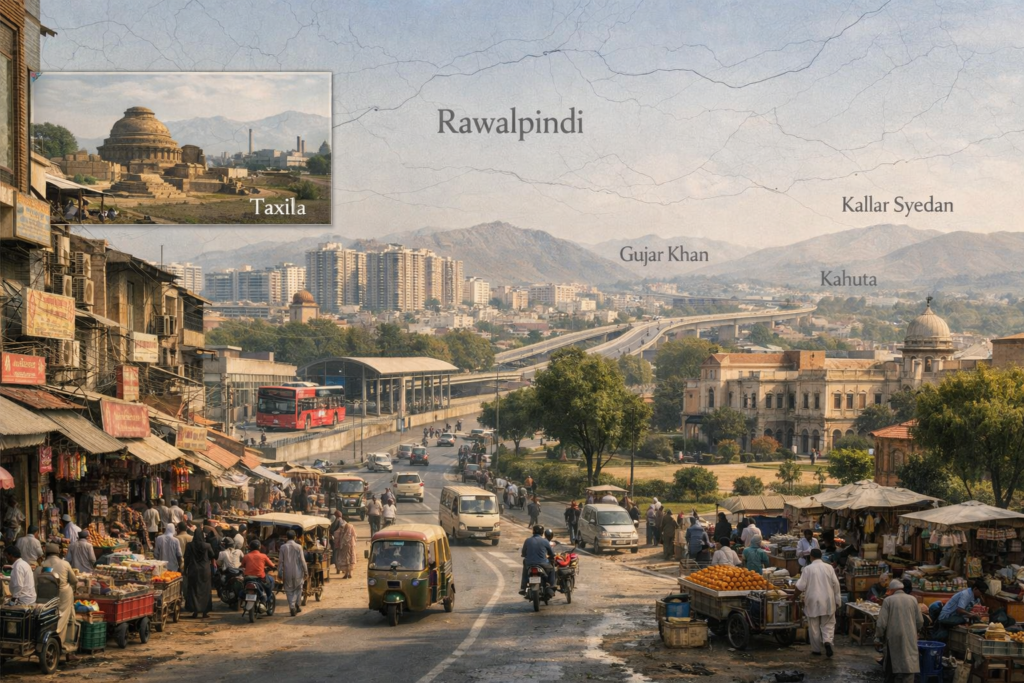
As a result, Rawalpindi district now consists of seven tehsils. The former single urban tehsil has been reorganized into three separate tehsils to better manage the large urban population. These are City, Saddar, and Cantonment. The remaining four tehsils are Gujar Khan, Taxila, Kahuta, and Kallar Syedan. There are also proposals under consideration by the Punjab government to create additional tehsils, including the possible bifurcation of Gujar Khan to create a Daultala tehsil. The Rawalpindi Division, which includes the newly formed Murree District along with Rawalpindi, Attock, Chakwal, Jhelum, and Talagang districts, is now the largest administrative division in Punjab.
| Tehsil | Major Areas and Towns | Key Characteristics |
| Rawalpindi City | Raja Bazaar, Committee Chowk, Dhok Hassu, Pirwadhai, Tench Bhatta, Adiala Road | Core urban center, old city commercial hub |
| Rawalpindi Saddar | Saddar Bazaar, Bank Road, The Mall Road, Satellite Town, Chaklala Scheme III | Commercial and administrative heart |
| Rawalpindi Cantonment | Westridge, Lalkurti, Chaklala, PAF Base Nur Khan, GHQ area | Military cantonment zone |
| Gujar Khan | Gujar Khan City, Bewal, Mandra, Jatli, Daultala, Rawat | Largest tehsil by area, agricultural heartland |
| Taxila | Taxila City, Wah Cantt, Heavy Industries area, Taxila Museum | Industrial zone with UNESCO heritage sites |
| Kahuta | Kahuta City, Beor, Nara, Hanesar | Hilly terrain east of city |
| Kallar Syedan | Kallar Syedan City, Choha Khalsa, Sir Soba Shah, Bishandot | Semi-urban tehsil south of the city |
Rawalpindi City Tehsil
It covers the oldest and most densely populated core of the urban area. It includes the historic Raja Bazaar, the main commercial hub of the region, along with neighborhoods like Committee Chowk, Pirwadhai, Dhok Hassu, and Tench Bhatta. This tehsil is the heartbeat of the district’s trade and everyday life, with narrow streets, bustling wholesale markets, and a population density that is among the highest in Pakistan.
Rawalpindi Saddar Tehsil
Saddar tehsil encompasses the commercial and administrative center of the city. It includes Saddar Bazaar, Bank Road, The Mall Road, and the well-known Satellite Town residential area. This part of the city has been a major shopping and business district since the British colonial era and continues to serve as the main commercial corridor. Chaklala Scheme III and several government offices are also located within this tehsil.
Cantonment Tehsil
The Cantonment tehsil covers the military zone of the city, including Westridge, Lalkurti, Chaklala, and the areas around the General Headquarters of the Pakistan Army. The Cantonment Board manages infrastructure and civic services in this zone. PAF Base Nur Khan and various military housing colonies fall within this tehsil.
Gujar Khan Tehsil
Gujar Khan is the largest tehsil in the district by area. It lies to the south and southeast of Rawalpindi city. The tehsil is predominantly rural and agricultural, with Gujar Khan city serving as its headquarters. The area is known for its agricultural output and for being the ancestral homeland of many overseas Pakistanis, particularly those settled in the United Kingdom. Other important towns include Bewal, Mandra, Daultala, Jatli, and Rawat. The tehsil has excellent road connections including the GT Road and the M-2 Motorway, and the upcoming Ring Road passes through its western edge.
Taxila Tehsil
Taxila tehsil lies to the west of this city and includes the historically significant Taxila archaeological site, a UNESCO World Heritage Site. The ancient city of Taxila was a major center of Buddhist learning and Gandhara civilization dating back over 2,500 years. Today, the tehsil includes the industrial city of Wah Cantt, which houses the Pakistan Ordnance Factories and Heavy Industries Taxila (HIT). The Taxila Museum is a major attraction preserving artifacts of the Gandhara period. The area is a unique blend of ancient heritage and modern industrial development.
Kahuta Tehsil
Kahuta tehsil is situated to the east of the city and extends toward the Azad Kashmir border. The terrain here is hilly and less developed compared to the central urban areas. Kahuta town serves as the headquarters. The tehsil is known for its natural beauty, rural character, and connections to the hills that feed seasonal streams into the Soan and Ling river systems. Dadhocha Dam, a critical water supply project for the city, is being constructed in this tehsil’s vicinity.
Kallar Syedan Tehsil
Kallar Syedan lies to the south of this city. The tehsil is named after its headquarters town and features a semi-urban landscape with a mix of agricultural land and growing residential developments. It serves as a transitional zone between the urban sprawl of Rawalpindi and the more rural areas to the south and east. Important settlements include Choha Khalsa, Sir Soba Shah, and Bishandot.
Population and Demographics of Rawalpindi
Rawalpindi is among the most populous districts in Pakistan. According to the 7th Population and Housing Census (the Digital Census) conducted in 2023, the total population of this district stands at approximately 5,745,964. This figure reflects the district’s boundaries after the separation of Murree, which took with it a population of about 372,947 (counted separately under Murree District in the 2023 Census). For comparison, the 2017 Census had recorded a combined population of approximately 5.4 million for the entire undivided RWP district including Murree and Kotli Sattian.
The urban population of this district accounts for over 70 percent of the total, with approximately 4.03 million people living in urban areas as per the 2023 Census. Rawalpindi city itself, with a population estimated around 2.43 million in its urban core, remains one of the ten largest cities in Pakistan. The city’s population density is among the highest in the country, particularly in areas like Raja Bazaar, Saddar, and the older inner-city neighborhoods. The literacy rate across the district stands at 83.05 percent, which is among the highest in Punjab, with male literacy at 87.63 percent and female literacy at 78.28 percent.
Ethnic and Linguistic Composition
Its population is ethnically diverse. According to the 2023 Census, about 56.7 percent of the district’s residents identified Punjabi as their mother tongue, with the Pothohari dialect being the traditional local variant. Urdu was the mother tongue for 16.6 percent of the population, reflecting the city’s role as a major urban center attracting settlers from across the country. Pashto speakers accounted for about 10.3 percent, a testament to decades of Pashtun migration that has significantly shaped the commercial and cultural landscape of the city. Hindko speakers constituted around 2.3 percent, Kashmiri speakers about 1.4 percent, and various other languages made up the remaining share.
Major Areas and Localities in Rawalpindi City
Rawalpindi city is a sprawling urban center with dozens of well-known localities and neighborhoods. The city’s urban layout reflects its organic growth over centuries, from the old walled city to modern planned housing societies.
Saddar and Cantonment Area
Saddar is the commercial heart of the city and has been a major shopping and business district since the British colonial era. The area includes Bank Road, The Mall Road, and numerous shopping plazas. Adjacent to Saddar is the Cantonment, one of the largest military cantonments in Pakistan. The Cantonment Board manages a significant portion of the city’s infrastructure in this zone, including roads, parks, and public services.
Raja Bazaar and the Old City
Raja Bazaar is one of the oldest and busiest commercial markets in the country. Located in the heart of old city, it is famous for wholesale and retail trade in textiles, electronics, spices, and household goods. The narrow streets and dense commercial activity give Raja Bazaar a character that is distinct from any other market in the twin cities. The old city area also includes historic neighborhoods such as Bhabra Bazaar, Sarafa Bazaar, and Bohar Bazaar.
Satellite Town and Westridge
Satellite Town is one of the first planned residential areas in this city, developed in the 1960s and 1970s. It remains a well-regarded middle-class residential neighborhood with a mix of commercial and residential zones. Westridge is primarily a military housing area connected to the cantonment. Both areas are centrally located and well-connected to other parts of the city and to Islamabad.
Chaklala and Airport Area
Chaklala is a prominent residential and military area in this city. It houses PAF Base Nur Khan and the former old Chaklala airbase (the old Islamabad Airport). The area includes Chaklala Scheme III, a well-established residential neighborhood, and several commercial zones. While the new Islamabad International Airport opened in 2018 near Fateh Jang in the adjoining area, the Thalian Interchange and Srinagar Highway extension have become the primary access routes. The broader airport corridor is increasingly developing into an integrated aerotropolis zone connecting Rawalpindi, Islamabad, and surrounding areas.
Bahria Town and DHA
Bahria Town and Defence Housing Authority (DHA) Islamabad-Rawalpindi are two of the largest private and semi-private housing societies in the region. Bahria Town is located along the GT Road and Islamabad Expressway near Rawat, and is one of the largest private housing developments in Asia. It includes commercial areas, educational institutions, hospitals, and recreational facilities. DHA spans areas near the Islamabad Expressway and offers premium residential and commercial plots. Both developments have significantly reshaped the real estate landscape of the region.
Other Important Areas
Other notable areas in and around the city include Pirwadhai (a major inter-city transport hub), Dhok Hassu, Adiala Road, Airport Housing Society, Gulzar-e-Quaid, Askari residential areas, Morgah, Tench Bhatta, and the rapidly developing zones along Adyala Road and Chakri Road. The growth of these peripheral areas has been accelerated by the Rawalpindi Ring Road project, which is creating new access points and economic corridors.
Economy and Industry
The district has a diversified economy supported by trade, services, manufacturing, military spending, and its proximity to Islamabad. The city is one of the largest commercial centers in Pakistan, with Raja Bazaar and Commercial Market serving as hubs for wholesale and retail trade. The presence of the Pakistan Army’s General Headquarters and related defense institutions generates significant economic activity, including defense procurement, logistics, and support services.
The Taxila and Wah Cantt area is a major industrial zone, hosting the Pakistan Ordnance Factories, Heavy Industries Taxila, and several private manufacturing units. Small and medium enterprises operate across the district, particularly in sectors like food processing, textiles, construction materials, and light manufacturing.
The real estate and construction sector has seen massive growth in recent years, driven by housing societies like Bahria Town, DHA, Capital Smart City, and numerous smaller developments along major road corridors. The Rawalpindi Ring Road is expected to further stimulate real estate development and commercial activity along its route. Agriculture remains important in the rural tehsils, with crops including wheat, maize, groundnuts, and vegetables grown across the Pothohar Plateau.
Major Infrastructure and Development Projects
Rawalpindi Ring Road
The Rawalpindi Ring Road (RRR) is one of the most significant infrastructure projects in the city’s history. This 38.3 kilometer, six-lane controlled-access highway is designed to divert heavy traffic away from Rawalpindi’s congested city center. The road starts from Baanth on the GT Road near Rawat and terminates at the Thalian Interchange on the M-2 Lahore-Islamabad Motorway, close to the New Islamabad International Airport. The project includes five major interchanges at Baanth, Chak Beli Khan, Adyala Road, Chakri Road, and Thalian.
Construction, being carried out by the Frontier Works Organization (FWO) under the Rawalpindi Development Authority (RDA), was approximately 70 to 75 percent complete by late 2025. The revised project cost stands at around Rs 45 to 50 billion, up from the original Rs 23.6 billion due to inflation and design upgrades. The completion deadline has been set for early to mid 2026. A feasibility study for Phase II, extending the Ring Road from Thalian to Sangjani to connect with the CPEC route, was also initiated in late 2025.
Dadhocha Dam
Dadhocha Dam is a critical water supply project for Rawalpindi. Located approximately 25 kilometers from the city, near the village of Dadhocha on the Ling River that collects rainwater from the Murree and Kahuta hills, this dam is expected to supply up to 35 million gallons of water per day to the city upon completion. The dam is 123 feet high and 737 feet long, with a catchment area of 129 square miles. The project, estimated at Rs 12 to 14 billion, was inaugurated in late 2023 and construction has been progressing, though timelines have faced delays. The Water and Sanitation Agency (WASA) has also initiated a feasibility study for the water conveyance pipeline and filtration plant to bring treated water from the dam into the city’s supply network.
Transport and Connectivity
This city enjoys excellent transport connectivity. The city is connected to the rest of Pakistan through the Grand Trunk (GT) Road, one of the oldest and most important road networks in South Asia. The M-2 Motorway connects Rawalpindi to Lahore, while the M-1 Motorway links it to Peshawar. The Islamabad Expressway provides direct access to the federal capital.
The Rawalpindi-Islamabad Metro Bus service, inaugurated in 2015, operates between Saddar Rawalpindi and Pak Secretariat in Islamabad, covering a distance of approximately 22 kilometers. This rapid transit system has improved daily commuting for hundreds of thousands of residents. In the broader context of Punjab’s evolving transport initiatives, discussions around the integration of feeder routes and electric bus shuttle services have been part of recent provincial transport planning, aiming to extend modern transit options to underserved areas of the twin cities.
Rawalpindi Railway Station is a major junction on the Pakistan Railways network, connecting the city to Karachi, Lahore, Peshawar, and Quetta through various express and passenger trains. The New Islamabad International Airport, accessible via the Thalian Interchange and Srinagar Highway extension, serves as the primary air travel hub for the twin cities and has become the anchor point for a growing aerotropolis corridor.
Education and Healthcare
Educational Institutions
Rawalpindi has a well-established educational infrastructure and was ranked the number one district in Pakistan in terms of education and school infrastructure facilities in a 2015 assessment. The district is home to several universities including Fatima Jinnah Women University, Arid Agriculture University (Rawalpindi Campus), and the University of Engineering and Technology (Taxila Campus). Military institutions such as the Army Medical College and Military College of Signals are also located here. There are hundreds of public and private schools, colleges, and vocational training centers spread across the district.
Healthcare Facilities
The district has multiple major hospitals. The Holy Family Hospital and Benazir Bhutto Hospital (formerly General Hospital, located on Murree Road) are among the largest public healthcare facilities. The District Headquarters (DHQ) Hospital Rawalpindi, located in the Raja Bazaar area, serves the central city population. Military healthcare includes the Combined Military Hospital (CMH) and the Armed Forces Institute of Cardiology (AFIC). The Fauji Foundation Hospital in the Cantonment area is another major facility. The proximity to Islamabad also gives residents access to hospitals in the capital, including PIMS and Shifa International Hospital.
At the primary healthcare level, the district operates numerous Basic Health Units, Rural Health Centers, and dispensaries spread across all tehsils. The construction of Dadhocha Dam is also expected to improve public health outcomes by providing a cleaner and more reliable water supply to the city.
Historical and Cultural Significance
Rawalpindi has a rich historical heritage spanning thousands of years. The Taxila archaeological site within the district is one of the most important in South Asia, with remains of Buddhist monasteries, stupas, and the ancient Gandhara civilization dating back to the 5th century BCE. Taxila was once a renowned center of learning that attracted scholars from across the ancient world and was visited by Alexander the Great in 326 BCE.
During the Sikh Empire, Rawalpindi served as an important garrison town. The British further developed it as a major military cantonment after 1849, and much of the city’s infrastructure, including the cantonment layout, railway station, and colonial-era buildings, dates from the British period.
After the creation of Pakistan in 1947, Rawalpindi served as the interim national capital from 1959 to 1967, before the federal government shifted to the newly constructed Islamabad. The city’s Ayub National Park and Liaquat Bagh (the site of the assassination of former Prime Minister Benazir Bhutto in 2007) are landmarks of national historical importance.
Culturally, it reflects the traditions of the Pothohar region. The local festivals, food, and folk traditions carry the distinct flavor of Pothohari Punjabi culture. The annual Urs celebrations at various shrines, the vibrant bazaar culture, and the culinary traditions, especially the famous Rawalpindi style chapli kebabs and traditional breakfasts, are cherished parts of the local identity.